-
Enterprise
 Premium Parcels
 Roadway ROW
- Data Store
- Regrid App
- Esri Users
-
Resources
 Support
 Content
 Programs
.png) Shop
Shop
- Contact Us
- Hide Menu


Intro
The California portion of the US-Mexico border (image source: Mapbox)
The US/Mexico border spans about 2,000 miles, four states and an incredibly diverse array of biomes ranging from major urban areas to swaths of desert. In recent years, the border (and immigration more broadly) has become a political flashpoint. The proposed construction of a physical wall spanning the entire southern US border has been a central point of the conversation since Donald Trump's election in 2016.
Here at Loveland, we realized that our nationwide parcel data was perfect to answer some basic questions that we hadn't heard much about in the media coverage. Specifically:
1) Who actually owns border parcels where the wall is being proposed?
2) What does current land use look like along the border?
Start with some context below, or
skip right to our analysis by clicking here.
Background
The location of the border as we know it today is a result of concerted US efforts to annex, purchase, or otherwise acquire Mexican land, notably the Mexican-American War in 1846-1848. Prior, most of what today is the southwestern United States was Mexican territory.

Mexican Territory, 1824
This knowledge is important, because it frames a central truth: the border is an artificial construct, which was drawn without much consideration for how people living in the region actually moved around. For many, this meant that journeys that had once been straightforward - to work, to visit family members, to graze livestock - now involved cross-border travel.
Over time as the U.S-Mexico border became the busiest border crossing in the world, US antipathy to illegal immigration increased as well. This antipathy was codified in 1965, when the passage of the Immigration & Nationality Act capped the number of Mexican immigrants that would be permitted annually. By 1972, the number of illegal immigrants in the US had topped an estimated 1 million.
In the years since, the debate around immigration has become increasingly heated and highly divisive. A central feature of Donald Trump's successful Presidential campaign in 2016 was a pledge to clamp down on illegal immigration and build a border wall that would more successfully keep out those who were entering the US illegally.
The Current Border Wall
 Prior to 2017, there were 654 miles of existing barrier along the border: 354 miles of pedestrian barriers, and 300 miles of “anti-vehicle fencing” (BBC, Sept 2019).
Since Trump took office, about 341 miles of new barrier have been constructed according to the Department of Homeland Security, in addition to some replacement of existing sections. The administration’s stated goal is to build 450 miles before the end of 2020 (Fox News, June 2020) with a current, ongoing push to meet that goal (WSJ, Oct 2020).
This is far less ambitious than initial proposals, which first called for a wall along the entire 2,000-mile span, and which Trump later revised down to about 1,000 miles before settling on its current goal of 450.
There are two primary reasons cited for the delays in wall construction:
1) Ongoing funding battles with the budget between the administration and Congress
2) Difficulties in acquiring private land along the border to build on.
At Loveland, this second point was especially interesting to us. We hadn’t seen much analysis of land along the border (especially broken out by owner type), so we thought we’d tap our nationwide parcel dataset to shed some light. We used a ½ mile buffer along the border to define our area of interest, and used our in-house data to obtain the stats you see in this report and associated map.
(Want to read more detail about our methodolgy? Jump to Methodology section)
Potential Environmental Impacts of a Wall
The Rio Grande serves as a natural boundary between the US and Mexico for almost the entire Texas portion of the border. As seen here, land near the river can support agriculture and other uses in an otherwise arid and desertlike part of the world.
Complicating this effort is the fact that much of the US-Mexico border is the Rio Grande, whose water in an arid landscape has been a draw for humans and wildlife alike for centuries. The Rio Grande also provides critical habitat for wildlife and harbors a huge amount of ecological diversity, in addition to sustaining agriculture along its length.
Native lands predate the modern border and their inhabitants, like the Totono O’odham Nation, are now increasingly caught up in regional geopolitics. Here, a view of the Totono O'Odham Nation bisected by existing wall.
The construction of the wall through wildlife areas poses a threat to these ecosystems, since physical barriers impede the transition of wildlife through their habitat. Surveillance technology (towers, sensors, etc) is already deployed in border-adjacent parks and accepted by park authorities as less harmful than a physical wall; during the Trump administration, however, pressure has mounted to build physical walls in these reserves as well.
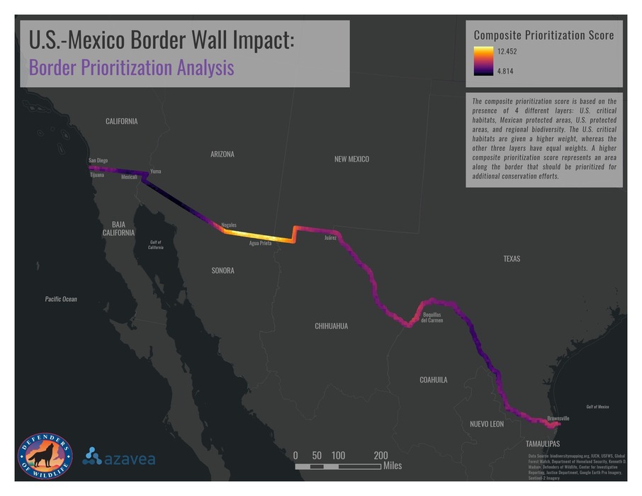
A map showing the relative sensitivity of the ecosystems along the border, from this excellent blog post on the border's environmental impact. A higher score (lighter/yellow) indicates areas that should be prioritized for conservation.
Land Along the Border Wall
Until recently, wall construction during the Trump administration has been primarily replacement and strengthening of barrier sections that already exist on federally controlled land. As the administration moves forward with its plans, especially if it wants to build new wall sections, it’s going to increasingly run up against land owned by private owners. Building wall segments on private land has historically been difficult, complicated, and unpopular.
The fact that only about 40% of parcels along the border are currently owned by public entities speaks to the potential logistical difficulties that arise when attempting to build a physical barrier along the border. Eminent domain, the legal mechanism by which the government can take private lands for public use, is not popular given Americans’ deeply held beliefs about private ownership: public opinion polling consistently shows that Americans dislike the practice generally, so there is likely some political risk to using this approach. However, in cases where private owners are otherwise unwilling to sell, it may end up being the only option.
As an additional logistical difficulty, Native lands span the border and their inhabitants, like the Totono O’odham, are now increasingly caught up in regional geopolitics.
Land Use
In Landgrid’s data, the key data that we have available to us to analyze land use is the LBCS (Land Based Classification System) codes. Designed by the American Planning Association, LBCS is an attempt to categorize all land uses that could happen on a piece of land along a few dimensions, and here at Loveland we're implementing these classifications (with some custom tweaks based on our user needs) across our national dataset (see 'Methodology' section for more on LBCS and how we've used it in this project).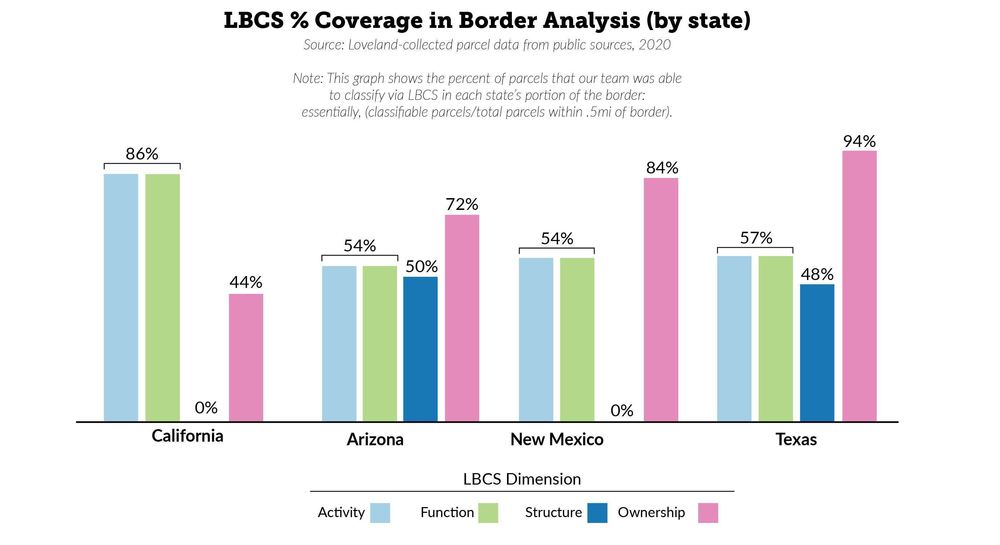
LBCS data along the border is somewhat patchy, mostly as a result of patchy underlying parcel data. In total, just under 60% of properties in our analysis are classifiable by activity and function, 87% by ownership (this is covered in more depth in the 'Ownership' section below), and only 44% by structure (because LBCS Function and Activity are similar, it's generally the case that if we're able to classify on one of these dimensions, you can also classify on the other - that's why the activitiy and function % coverage is identical by state in the above chart). We feel that this is enough data to shed significant light on the shape of border parcels, although we'd love a more complete dataset in the future.
You can look at all the LBCS categories on the interactive map that accompanies this article.
Ownership
Using Loveland's data which generally contains owner name, we were able to use this information to parse ownership into four broad categories.

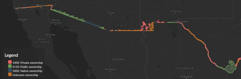
Native Land
While their number is a small percentage of the total parcels (just 272 out of 116,675 parcels in our dataset), Native owned lands are often geographically extensive. Because tribal lands far predate the border as it currently exists, Native Americans living in these areas often find themselves caught both literally and figuratively in the middle of border politics. For our analysis, parcels are categorized ‘Native Land’ when the owner listed on the parcel contains the keywords “Indian”, “Tribe”, or “Nation”. We consider as "native lands" parcels which are held in trust for native peoples by the federal government as well.
Public Land
Federal and state government currently owns about a third of the land along the US/Mexico border. A patchwork of entities comprise this section: some examples of these entities include school districts, the Bureau of Land Management, State Parks and Recreation departments, Department of Homeland Security, and of course properties with owner names like “UNITED STATES”.
Private Land
Private ownership accounts for 83% of all parcels along the border, and 36% of the total acreage. When parcels have ownership information but do not fit into either Native or Public categories, we have assumed that they are privately owned; this was borne out by extensive spot-checking of the data, and although there is always room for error, we feel confident that this is a sound approach.
Unclassified
Parcels get an ‘Unclassified’ designation when ownership info is not available.
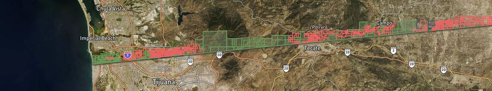
Detail of our interactive map showing a portion of the border by owner type
Top Owners Along the Border
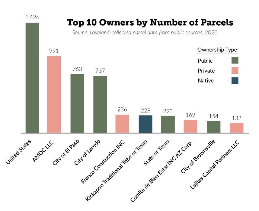
As might be expected, the federal government is the largest owner whether looking by acreage or number of parcels. Private owners constitute 7 of the top 10 land owners when looking by acreage.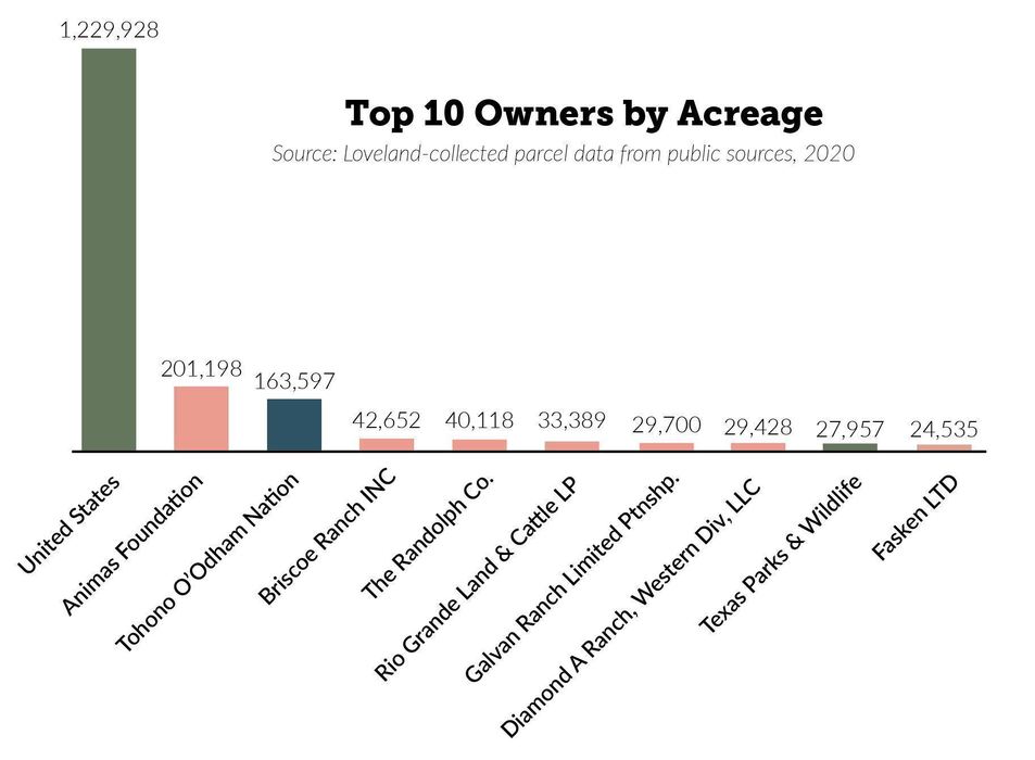
Ownership by State

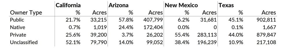
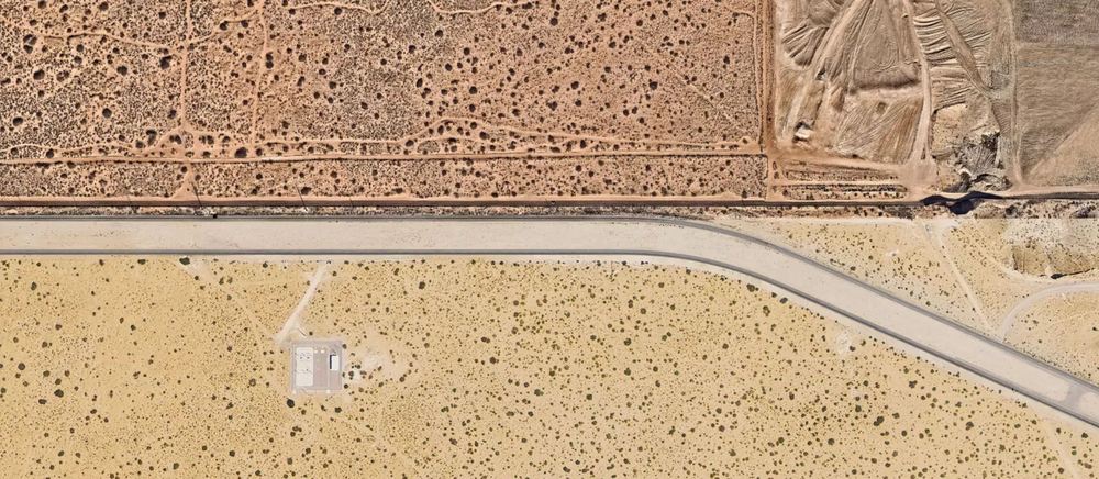
California
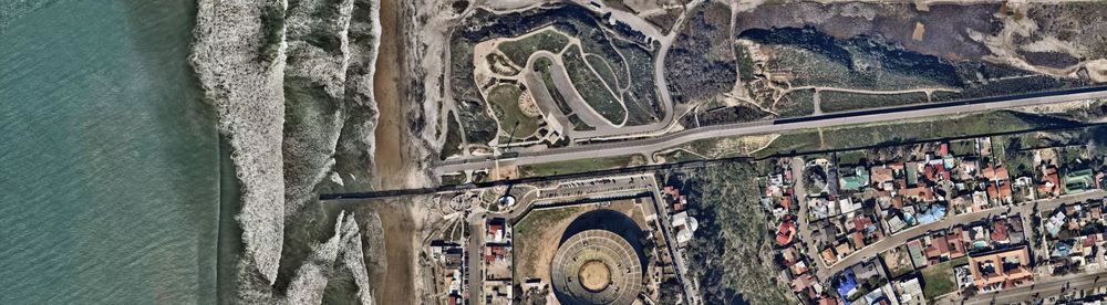
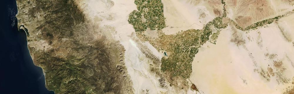
The westernmost portion of the border, as it meets the Pacific Ocean in California (source for all satellite images: Mapbox)
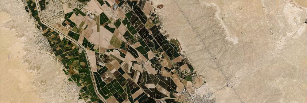
There are 8,056 parcels along the California portion of the border. Of the four states that comprise the border, California’s is the shortest in terms of length - however, it houses many of the busiest border crossing sites, due primarily to the large urban centers close by in both countries.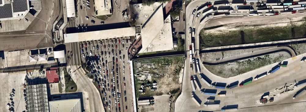
Otay Mesa crossing, California
California’s relatively strong data privacy laws mean that ownership information is scarce compared to the other states analyzed for this report.
Arizona

.png)
Ciudad Morelos / Somerton border, Arizona
Arizona has by far the fewest privately-owned parcels by acreage along the border - just 3.7%, as compared to the overall border-wide statistic of 36.4%.
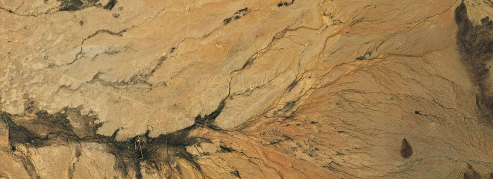
The Arizona portion of the border is some of the most punishing and remote, consisting mostly of desert and low scrub punctuated by rocky outcrops. Much of this land is publicly owned (57%), and the majority of the Arizona border has some existing fencing in place.
New Mexico
New Mexico border, west of El Paso
New Mexico’s western half of the border continues in the same remote vein as Arizona’s, and in the east ends just before the major border city of El Paso. Unlike New Mexico however, more than half of all ownership is in private hands (55%).
Texas
The border just south of El Paso, TX
The Rio Grande is the US/Mexico boundary for the entire Texas portion. While the river has historically served as a natural barrier, its presence complicates any plans to build a wall to further impede illegal entry, since in such an arid area the presence of a water source is a natural draw for humans and animals. The delicate status quo could easily be disrupted by a barrier wall - causing concern among environmentalists and farmers alike.
Texas also has by far the highest number of privately owned parcels of any border state, making any serious effort to build new sections of wall likely to end in eminent domain battles as existing owners fight to keep their land and access to the river. Previous attempts resulted in widespread allegations that the government was lowballing citizens, that the whole process was haphazard and full of mistakes, and that many owners weren’t treated fairly.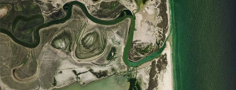
The westernmost portion of the border, where the Rio Grande empties into the Gulf of Mexico
LBCS Activity
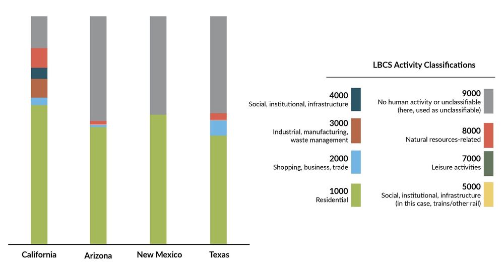
As seen in the chart above, when parcels are broken down by activity the predominant use by far is residential. Agriculture, in contrast (8000 code) takes up a remarkably small proportion of land use along the border. This may be truly representative - however, it's worth bearing in mind that it could be the case that our incomplete data regarding parcels could distort this analysis. For example, agricultural parcels may be disproportionately likely to have sparse data with which to classify them, or parcels which are predominantly agricultural may be classified as 'residential' when a house is present as well, possibly skewing the numbers.
Contributors
This report was assembled by Loveland Technologies using Loveland's parcel dataset.
To purchase our data, please visit our parcel data page
If you'd like to get in touch or have questions, drop us a line at team@landgrid.com!
Staff contributors:
Nick Downer, Matthew Klovski, Ray Visser 
Methodology
The first thing we did was to define how far from the border our analysis should reach; on balance, we determined half a mile. We clipped the parcels within this area of the border, and used that subset of our national dataset to work with henceforth.
LBCS Classifications at Loveland
One of the contributors to this article, Ray Visser, has written previously in some depth about our LBCS process; that's the best place for a comprehensive overview on that front.
Owner information
Loveland collects ownership information by parcel along with the multitude of other data that is publicly available nationwide. For this project, the central issue was how to meaningfully group together owners into types that gave us a look into what ownership on the border looked like.
The general approach was as follows:
- Use SQL regular expressions and a predetermined list of search terms to parse parcel "owner name" values for recognizable patterns and keywords denoting various owner types (eg native, private, public)
- Spot-check the results for errors (e.g., "US BANK" or "SOUSA, JOHN PHILIP" should not receive "federal government" ownership classifications despite matching the regular expressions).
- Apply the proper LBCS ownership code to the resulting parcels.
- Repeat steps 1-3 for state, county, municipal, Native, and educational owners.
- Sort the remaining unclassified parcels by unique owner and total acreage owned and extensively spot-check the results to catch major outliers whose owner names don't match regular expressions due to misspelling, unusual abbreviation, etc. (e.g.. "U S OF A" or "NATL PARK SVC")
- Apply the proper LBCS ownership codes to those outliers.
- Again, sort the remaining unclassified parcels by unique owner and total acreage, this time filtering out owner names which shouldn't have any classification by nature (i.e. 'Undefined: EXTENSIVE DEED RESEARCH REQUIRED" or "UNKNOWN").
- Determine that, after steps 1-7, if an unclassified parcel is not owned by federal, state, county, municipal, Native, educational, or unclassifiable entities, it must therefore be privately owned, and apply the proper LBCS ownership code to the remaining parcels.
Disclaimer: This is a process which undergoes constant internal refinement, and we extensively spot-checked the classification process at every step. However, human limitations (both in variation in phrasing, abbreviation, spelling, etc. of owner names provided by local assessors, and in the time able to be dedicated to the project) means the classification we present here is not guaranteed to perfectly represent the ownership characteristics of the dataset. Even in a small portion of the nationwide parcel layer like we find along the US-Mexico border, it is infeasible to double-check every one of more than 116,000 entries for accuracy.
Below is a sample of the SQL used to categorize into each group:
Native ownership
select distinct owner
from border_parcels
where
(owner ~* 'tribe'
or owner ~* 'tribal'
or owner ~* 'indian'
or owner ~* ' nation'
or owner ~* '[^p]reservation')
and
(owner !~* 'inc' and owner !~* 'llc' and owner !~* 'l l c')
group by owner;
Owner type by county: spreadsheet form