-
Enterprise
 Premium Parcels
 Roadway ROW
- Data Store
- Regrid App
- Esri Users
-
Resources
 Support
 Content
 Programs
.png) Shop
Shop
- Contact Us
- Hide Menu


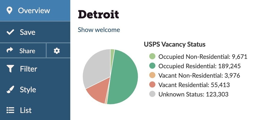
Address-level insights into which properties are vacant, and which are residential.
Landgrid has integrated powerful nationwide vacancy and residential indicators from the United States Postal Service. To access this amazing data on our platform, sign up or upgrade to Landgrid Pro for just $10/month or $100/year. Contact sales@landgrid.com if you'd like to purchase this data in bulk.
Residential Delivery Indicator: Whether an address is shown to be residential (someone lives there) or not.
Y means it is classified residential; N means it is not.
Vacancy Indicator: Whether an address is vacant or not (as determined by local postal worker).
Y means it is classified vacant; N means it is not.
Vacancy Indicator Date: The date that the vacancy indicator data was last updated.
As a general rule, this data is updated monthly.
Upgrade to Pro Download sample Detroit data (csv)
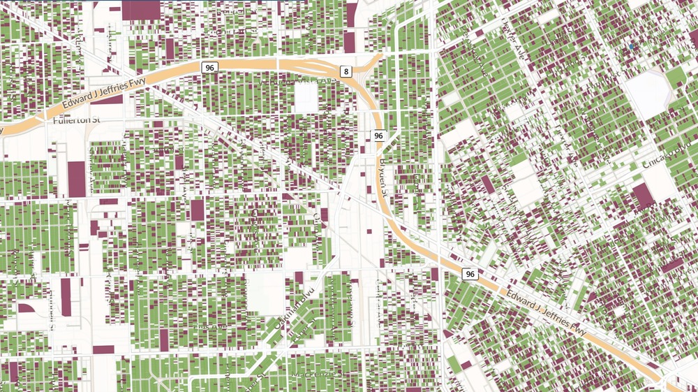
How to filter and style the USPS data
This dataset indicates when a building of any zoning type is not receiving mail. It is the perfect out-of-the-box dataset to start understanding vacancy in your community.
To show data on the map using your Pro or Enterprise account, just do the following:
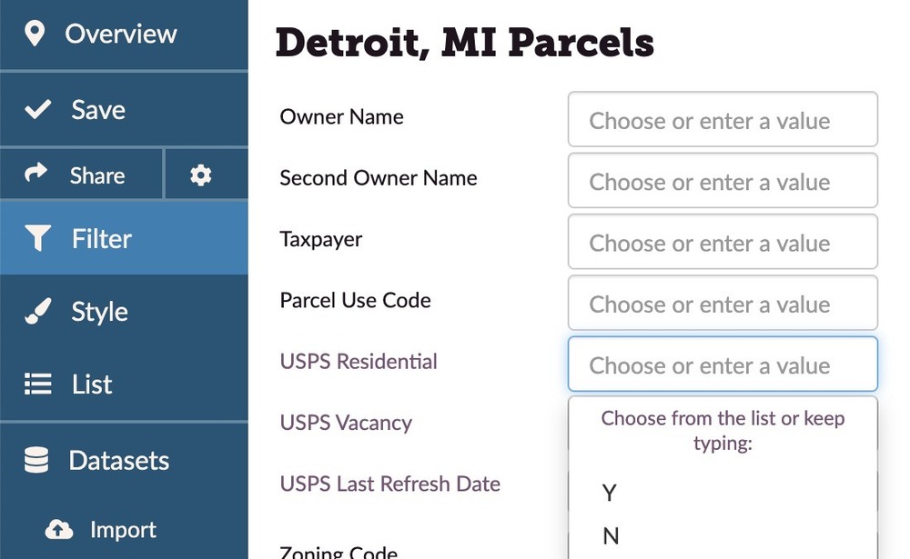
1. Navigate to the "Filter" function on the map UI
2. Go to "USPS Vacancy" and select "Y"
3. Do the same with "USPS Residential" field.
4. Then click "Load on Map" & see those vacant & residential parcels light up the map along with the count of parcels for the matching query within any boundary - county, city, neighborhood, zipcode & census!
5. Press save & give your project a name in order to be able to quickly return to this vacancy view.
You can do the same & color code your maps for vacancy data using the "Style" function on the map UI!
Easy Peesy!
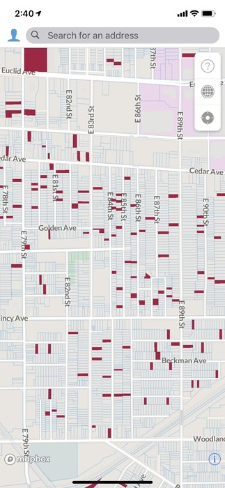
Surveying vacant properties using the Landgrid app
You now already have the vacant properties highlighted & saved to your project. Use this data to survey vacant properties next. This makes your & your canvassers' job easy & focused.
To start a survey of vacant properties, follow these quick steps:
1. Select "Survey" on the left hand panel of the map UI on the Landgrid Mapping Platform.
2. Use our "Survey Editor" to spin up a survey questionnaire in a matter of minutes.
3. Your survey will appear in the Landgrid App on your phone or tablet.
4. You can then start visiting properties to take pictures & notes on those vacant properties, which will automatically get loaded onto your map.
We're excited to provide you USPS vacancy data nationwide at the parcel level, something that to our knowledge has not been done before. While aggregated USPS vacancy data is a widely-accepted indicator and has been used in academic studies and research since at least 2010, there has rarely been a way to crack that data open and see how those aggregations have been made, or how reliable the data is.
While we know that the data is not perfect - and we hope that you get in touch with us to share your findings, so we can refine this dataset going forward - the Loveland team feels that this is an important tool for our friends and partners to have, and a revolutionary step forward in understanding the property dynamics in our communities. Happy Mapping!!!
Landgrid Parcel Data:
This data can also be licensed for use in your own system along with our other nationwide parcel data. Write to us at parcels@landgrid.com if you are interested.
USPS FAQs, disclaimers & limitations:
All things you need to know about the USPS Residential & Vacancy data, now available as part of our dataset & platform:
1. What is the USPS Vacancy & Residential data?
The United States Postal Service maintains a database of every deliverable address in the US.
This data is collected and maintained by their letter carriers.
As part of their regular processes, letter carriers identify addresses as either primarily residential or non-residential delivery points. That information is recorded as what the USPS calls their "Residential Delivery Indicator" (RDI).
There are times when the letter carriers record addresses that are valid addresses, but for some reason are not currently collecting their mail. This is recorded as a their "Vacant Flag". It is important to understand these addresses could receive mail, but are not currently receiving mail. This is different from addresses that are not considered valid for receiving mail, which are addresses that might be assigned to new developments where buildings have not been built or are not yet occupied.
2. What is the current match rate on Landgrid.com?
~89 million parcels currently have USPS data attached.
We have ~117 million addresses in our dataset and we have matched approximately 89 million of those addresses for a total match rate of 76%.
As this is our initial pass over the parcel addresses in our dataset, we expect to increase this number on subsequent passes over our dataset.
Additionally, counties typically only maintain 1 address per parcel and a significant percentage of those parcel addresses are non-deliverable parcels like farm fields or other vacant lands.
3. How frequently will this data be updated?
USPS data will be updated approximately every month as and when it is released by the USPS Certified Data Vendor we work with.
4. What are the limitations of this data?
- The USPS data is only available in our dataset where we have parcel address data, which is not the entire dataset. As a result, there will be a few places that may not have the USPS data.
- We currently don’t have buildings and unit level USPS data. We typically only have one unit per building, even if it's an apartment building so mileage on the USPS data may vary in high-density areas. So as a result, the vacancy indicator may apply to one or a few units within an otherwise occupied multi-unit dwelling.
- We have integrated this data as is into our dataset. USPS data itself can vary in accuracy. So please be aware that there might be some discrepancies with this data occasionally.
- USPS data is updated every month and we will do the same. The data may be inaccurate between updates due to changes in occupancy or demolitions that will not be reflected until the next data refresh.
- We will be working to ground-truth and improve the accuracy of this data moving forward. If you have observations about the USPS data in your area which you'd like to share with us in an effort to refine and improve the information, please contact Nick: nick@landgrid.com.
5. What are the limitations for USPS data usage as a Landgrid customer?
- Right now, this data is available on our mapping platform for Pro & above subscription tiers. Free users will need to upgrade to Pro in order to view the residential & vacancy data.
- Pro users can view, filter & style the USPS fields. However, Pro users will not be able to download the USPS data in any format.
- Enterprise and Team customers can view & export up to 50K rows of USPS data as a CSV.
- For bulk data downloads of USPS data, customers will need to license our bulk parcel data - https://landgrid.com/parcels. Please contact us at parcels@landgrid.com to get a quote & a data sample.
- We request our customers not to use the data for direct mail commercial marketing campaigns.